
Storms, volcanic eruptions, earthquakes, wildfires… the force of nature is unstoppable, and the most recent natural disasters have shown us that we underestimate its power and that, on many occasions, we are unprepared to deal with them. For this reason, the Spanish government has published a new Basic Civil Protection Planning Guideline regarding earthquake risk in the Official State Gazette (BOE).
These guidelines include updated information on new prevention measures and cooperation among regions, as well as a seismic risk map that categorizes the level of danger in each of the country’s municipalities and provinces.
Although the southeastern part of the peninsula is the most exposed area, the four provinces of Catalonia are located in areas with seismic intensity grades VI or VII (with grade VIII being the highest in Spain).
Seismic Risk Map: Which Municipalities Are Most at Risk
The province of Girona poses the highest seismic risk. Its entire territory is classified as a Grade VII area, due to the presence of active faults and tectonic activity in the Pyrenees. The new regulations require all municipalities to implement their own action plan in the event of an earthquake.
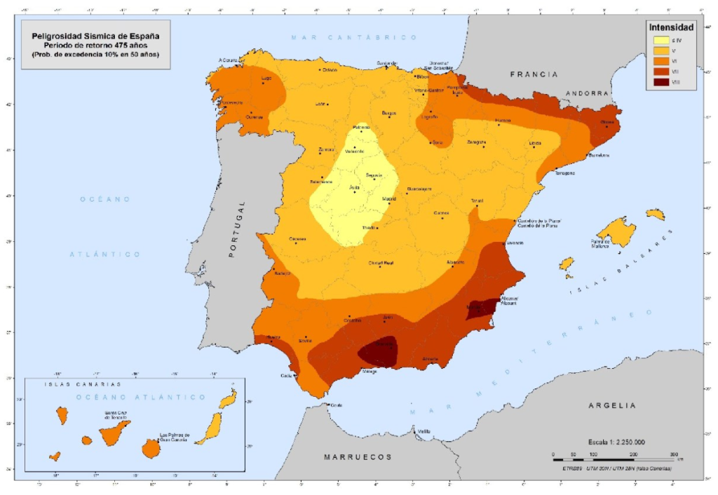
Barcelona and most of the province are classified as Level VI risk, which means these areas will be subject to the regional plan. However, more than 80 municipalities, mainly in the northeastern part of the province, will have to develop their own action plans, as they are located in a seismic intensity zone of VII.
The level of danger in the province of Lleida increases as one moves toward the Pyrenees. Although the provincial capital is in an area with intensity level V—which is relatively low—most of the territory of Lleida falls between intensity levels VI and VII.
Tarragona is the “luckiest” province because, although the northeast and the capital are located in intensity zone VI, slightly more than half of its territory is in intensity zone V.